Mungo National Park in the Willandra Lakes Regional World Heritage Area – Background briefing on landscapes and human history

b39
Lake Mungo floor with the lunette on the north and east side in the background. Mungo National Park

Lake Mungo and its past inhabitants

It is hard to appreciate when driving across the bed of Lake Mungo in semi-arid, southwestern New South Wales that this used to be up to 15 metre deep freshwater and spread over 200 square kilometre with an environment that provided favourable living conditions for the predecessors of the three local Aboriginal ‘tribes’. The Barkindji (Parkantiji), Nylampaa (Nglyampee), and Mutthi claim Willandra Lakes, including Lake Mungo, as their Traditional Land and meeting place.

Geomorphologists and climate scientists tell us that these lake-full conditions occurred before the last ice age during the period 50,000 ya to 25,000 ya when water was carried to Lake Mungo and the other local dry lakes, by Willandra Creek. About this time there had been a rise in the uplands of eastern Australia and a sinking of land in westward crossed by the Lachlan, Murrumbidgee and Murray rivers and their vast riverine plain. Like the other two rivers, the Lachlan River is/was fed by tributaries from the high country in eastern New South Wales.

A response of rivers flowing over flat riverine plains is the development of anabranches (river offshoot channels), long waterholes and billabongs. In the past Willandra Creek was the longest but not the only Lachlan River off-shoot and behaved as a river anabranch that flowed via the Willandra Lakes, including Lake Mungo, and eventually discharged into the Murray River. Today this creek is still a branch off the Lachlan River but only carries water short distances when the river floods.

The warm wet pre ice age period favoured a wide variety of plant growth, not the arid-adapted species we see today, and consequently there was a wide range of animals for food both on land and in the water for human consumption. Food sources would have included plant products like fruits, seeds, leaf and tubers and those from animals such as kangaroo, emu, reptiles, water birds and fish, and the collection of birds eggs, crayfish and mussels.
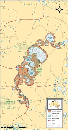
Map of the Willandra Lakes Region showing the World Heritage Area
Boundaries. Lake Mungo is in the middle of the chain of lakes.
From Wikipedia, 2020

Following assessment of many different date-measuring techniques (eg radio-carbon dating and optically stimulated luminescence (OSL)) from this burial site, a multi-disciplinary committee of archaeologists, national park personnel and indigenous Australians has assessed the male body to be older than that of the cremated female. In 2015, following requests from the Mungo National Park Traditional Owners, the skeletal remains were locked away and stored at the National Museum and in 2017 they returned to Lake Mungo for reburial.
Visitors to Mungo National Park see other evidence of past Aboriginal occupation by Indigenous guides including stone tools, hearth sites, middens and to hear about cultural practices. It is also possible to visit the woolshed and see other remains of the rural properties Mungo and Zanci that once operated here. Inside the Interpretation Centre visitors can also read about the history of the park including the gigantic Zygomaturus. This is an herbivorous megafauna species that grazed around the Willandra Lakes and became extinct about 33,000 to 37,000 ya.

Group with Aboriginal guide in Lake Mungo National Park inspecting an ancient camp site hearths and stone tools.

However, lake levels started to drop by 40,000 ya, with increasing fluctuation in their levels, and by the time the last ice age reached its maximum, 22,000 – 18,000 ya, the freshwater flows had stopped and the average temperatures had dropped by 6 -9 Celsius degrees. Willandra Lakes had dried up and in so doing had accumulated gypsum, crystallised from the evaporated water, on their surfaces and their Aboriginal population had dispersed.

Most of the evidence for human occupation in the Lake Mungo area is derived from artifacts and burial sites that date from the period 50,000 – 25,000 ya prior to the recent ice age, with one major exception. In 2003 there was the discover of many 100s of footprints along 25 individual tracks in mud that was dated from 20,000 ya. These have been rated as Australia’s oldest and only Pleistocene footprints. While most of the prints were human there were some marsupial and emu tracks in the mix.

In 1969 Jim Bowler, a geomorphologist from University of Melbourne, had been studying the crescent shaped dune (a lunette) found on the north and eastern shore of Lake Mungo and chanced upon human skeletal remains exposed by dune erosion. The cremated crushed bones were those of a female. This ceremonial burial took place about 42,000 ya and, to date, this is the oldest cremation known. In 1974 Jim also found the grave site of a man also revealed by wind erosion of the dune. This body had been buried with his arms crossed and covered with red ochre, which was assessed as a ceremonial material that had been sourced from 200 km away.

The Fascinating Lunette

The largest and most prominent feature in the National Park is connected to the eroding lunette on the north eastern side of the lakebed. Lunettes are crescent shaped sand dunes formed on the edge of lake and like most dunes result from the accumulation of wind-blown sediments. Prior to the introduction of rabbits and sheep the lunette maintained its natural vegetation cover and its original shape.

Beginning in 1864, stock grazing began denuding the area and there was the added problem of plant destruction and soil disturbance by rabbits that opened the lunette to wind and water erosion. Today feral goats accentuate the problems of the past. The eventual exposure of the lunette by erosion has revealed its make-up and its various layers as distinguished by the colour, soil texture and position of the remaining sediments.
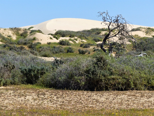
Recent eroded sand advancing over the lunette in a north easterly direction

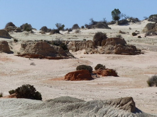
Eroded lunette with patch of the Gol Gol unit (foreground) and larger mounds of the Mungo unit.

The Lake Mungo lunette was shaped by south-westerly winds and originally, there was a continuous 24 km long, 20 m high ridge capping most of the lunette. Geomorphological and archaeological studies have determined that the lunette was formed on this eastern and north east side of the lake in three main phases following a full lake some 40,000 ya. In low water periods red dust from the plains mixed with beach sand from the lake which accumulated as low, wind-blown dunes that were stabilised by reed and other natural vegetation when it refilled. However as low water periods became more common after 35,000 ya, the persistent winds sweeping across the exposed floor of the lake were able to pick up dried clay and sand and deposited these above the red sands. This created brownish-grey sandy layers and as they accumulated were stabilised by vegetation.

As good seasons returned water levels rose again but more layers were added during the next low water period.
Geomorphologists named the red sand layer the Gol Gol Unit after one of the oldest local stations and the much thicker brownish-grey sandy layer above it the Mungo Unit.

These two layers are of most interest to archaeologists given that their formations coincided with the most affable period for human life around the lake. They extend some 200 m from the lake side to the outer edge of the lunette. The final stages of lake drying began 22,000 ya and by 19,000 ya the lake floor was bare and had accumulated gypsum. Dust of clay and gypsum from the lake began to be deposited as the upper layer of the dune. This is referred to as the Zanci Unit. The striking landform features resulting from erosion of this Unit and those below have been called The Walls of China.
Justification for this area to be classified as a UNESCO World Heritage site is based on three criteria as summarised by the Mungo National Park website. Two are based on natural features, the other of cultural history:

‘Natural: as an outstanding example representing the major stages in the Earth’s evolutionary history; and as an outstanding example representing significant ongoing geological processes. Cultural: bearing an exceptional testimony to a past civilisation.’
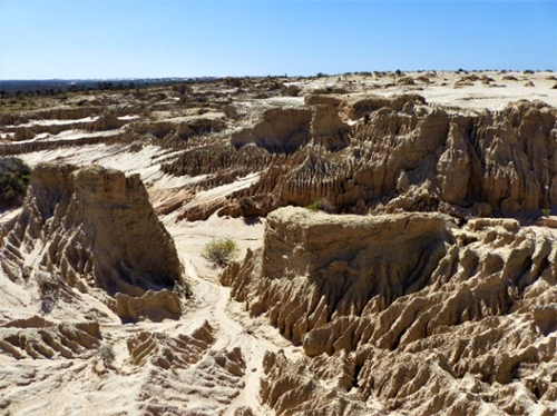
Water erosion and The Walls of China. Lake Mungo

Lake Condah and Budj Bim Cultural Landscape – Background briefing on landscapes and human history

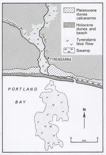
The Tyrendarra lava flow from Budj Bim covered land to its west and formed a long narrow 18km flow southward.
Currently it seems to end at the sea shoreline of Portland Bay but in fact the flow continued, during a period of low sea level, into the current Bay area for a further 15 km.
Lake Condah is situated in south western Victoria, south of Hamilton and north east of Portland and Hayward. The is known by the Gunditjmara people, the traditional owners or this area, as Tae Rak.
Interestingly the eruption of Mt Eccles in the northeast of this Cultural Landscape is recorded as a significant element in the traditional creation stories of the Gunditjmara, telling of the origin of their culture. and the mountain is given the traditional name of their creator Budj Bim.

The molten basalt of the Tyrendarra lava flow from Budj Bim (Mt Eccles) came from an eruption 36,900 +/- 3,100 years ago (ya). This was not its only eruption and the last occurred some 6,500 ya. Today Lake Surprise fills the craters of the now extinct volcano.

IMGP6810
Lake Surprise now fills three of the four craters of Mt Eccles, Western Victoria.

It is thought that the Lake Condah was formed by a wall of basalt that blocked off the natural drainage. Peat from the base of Lake Condah swamp has been dated at just over 6,000 (ya) a which gives an indication of when the lake may have formed.

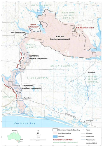
The World Heritage site, Budj Bim Cultural Landscape is divided into three components all based on rock from the initial Tyrendarra flow. Lake Condah, Darlot Creek, Budj Bim (Mt. Eccles) and the broad section of the Tyrendarra lava flow are contained in the northern component. The central component of this divided Cultural Landscape, Kurtonitj, also on the flow which is bordered on each side by the Fitzroy River on its west and Darlot Creek on the east. The southern component, named Tyrendarra, also has a north-south orientation. It is east of Tyrendarra township and contains the basalt and the wetlands between the river and the creek.

In response to the autumn and winter rains the basalt surface has produced a landscape with swamps, wetlands and low-lying land prone to flooding on each of the three Cultural Landscape components. These provide an ideal habitat for Kooyang, the short-finned eel, a fish that featured prominently in the lives of the Gunditjmara people for some 6 000 years.

The southern section of the Tyrendarra lava flow
on land and under Portland Bay
(adapted from E.C. Bird, The Coast of Victoria. MUP, 1993)

Location map showing Lake Condah, sections of
Budj Bim World Heritage site in southwestern Victoria
with their relationship to Darlot Creek and in the south-west to the Fitzroy River.
(adapted from the UNESCO via Creative Commons Licenses)

Elvers (juvenile eels) from the Southern Ocean move up the local streams like Darlot Creek then spread out to the wetlands where they mature into adult eels. The elvers may cross moist land surfaces to reach their destination where they live until they reach sexual maturity. Between the age of 15 and 30 years when the females reach maturity they are about a metre long; males are slower growing and smaller reaching maturity when 14 years old. At this stage these adults return to the salt water and migrate from the Southern Ocean to tropical locations like the Coral Sea off New Caledonia to mate and produce the next generation.

It is mainly at this mature size that the Gunditijmara would have caught the animals in an elaborate system built using waterways they have dug and barriers they have built from basalt stones as part of their cultural landscape.

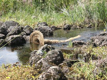
The barriers were fitted with platted tubular, tapered pot/trap and most trapping was during autumn as the adult eels begin their migration. The eels were caught as they emerged from the end of the pot, killed with a bite to the back of their head then used as fresh food or smoked as a means of preservation. Smoking was carried out by hanging the eels over smoky fires in the hollows of large eucalypt trees.

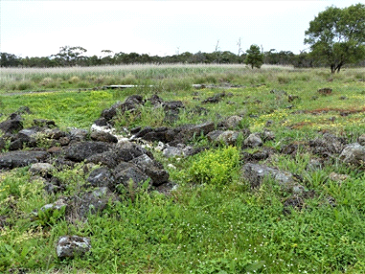
Ovegrown channel and built barrier.
Repaired barrier with eel pot. Tyrendarra.

The earthworks and built channels connected swamps allowing water movement in both directions. In similar ‘engineering’ at nearby Toolondo, channels up to 2.5 km were constructed to also join swamps and archaeologist Harry Lourandos calculated that 13,000 hours of labour would have been involved in the project. While several of the local engineering works may have begun in the order of 6,000 ya, it is suggested that the system at Lake Condah may be more recent than this.
Other Gunditjmara built structures in this region were the many horse-shoe shaped dry stone walls shelters using the basalt boulders. These foundations had relatively shallow walls and most were 2-3 m in diameter though some, at 4 m-5 m, would have been capable of housing eleven people.

Archaeologist Josephine Flood suggests these shelters provided temporary housing and were roofed with sticks and sheets of bark but that describing the aggregation of these structures as ‘villages of stone houses’, as suggested by some authors, is an exaggeration [see The Original Australians. A&U, 2006]. The shelters served a purpose when the eels were being harvested but the clan groups and families moved to other sections of their country in outside the eeling season.

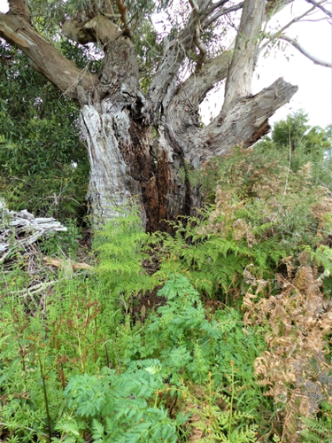
Remains of an aged eucalypt with the hollowed-out trumk that
had been used for smoking eels. Tyrendarra

Replica house built on one of the many shelter foundations found in Budj Bim

As a World heritage Area it is the most recently declared World Heritage site being Australia’s 20th and officially recognised by the UNESCO committee on 6th July 2019. The decision was based on the following main criterion that make it the only Australian World Heritage sites to be based only on cultural heritage.

Criterion (iii)
Gunditjmara knowledge and practices have endured and continue to be passed down through their Elders and are recognisable across the wetlands of the Budj Bim Cultural Landscape in the form of ancient and elaborate systems of stone-walled kooyang [eel] husbandry (or aquaculture) facilities.

Criterion (v)
The continuing cultural landscape of the Budj Bim Cultural Landscape is an outstanding representative example of human interaction with the environment and testimony to the lives of the Gunditjmara.