Gawler Ranges, Eyre and Yorke Peninsula – Background briefing – landscapes and natural history

Gawler Ranges

Eyre Peninsula,

Port Lincoln and Iron Knob

Spencer Gulf, Gulf St Vincent and Yorke Peninsula

Ores and Minerals

A W (Sandy) Scott. Nov. 2020

Gawler Ranges

In Australia there are three original stable and ancient landmasses (cratons) about which the rest of the continent has developed. Two of these, the Pilbara and the Yilgarn cratons are in Western Australia (WA) and the third, the Gawler Craton, is found in South Australia (SA). The Gawler craton is younger that those in WA with a section beginning 2450 Ma (millions of years ago) and it had stabilised by 1450 Ma. This craton underlies all of the Eyre Peninsula in SA reaching north near Olympic Dam, westward around the eastern part of the Great Australian Bight and eastward it stretches across toward the Adelaide Geosyncline at Whyalla and east of Lake Gairdner.

The three Australian cratons, the Pilbara (PC) and Yilgarn (YC) and the Gawler(GC) (Source Wikipedia Commons)
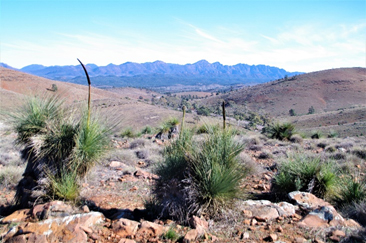
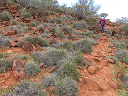
The weathered volcanic rock, Dacite and hummocks of porcupine grass (triodia sp..). Mt Ive, Gawler Ranges

The central section of the Gawler Craton was flooded around 1,600 Ma with volcanic lava flowing out from vents rather than volcanic cones. Shortly after there were some extrusions of Rhyolite which on cooling formed organ-pipe columns. The volcanic rocks, like Dacite, are well exposed especially on hills and other high country and have a beautiful red coloration resulting from the weathering of its iron-rich mineral components. Both the Volcanics and the Rhyolite are features in the Gawler Ranges National Park and other sections of the Gawler Ranges like Mt Ive.

[Mount Ive is the name of a landform and of a sheep station. Here the owners have upgraded some of its worker accommodation which is available to travellers. This property also holds the key allowing access to the National Park reserve area enclosing the southern section of Lake Gairdner.]

Rhyolite, Organ Pipe columns, north-west of Mt Ive.
Southern Lake Gairdner, Gawler Ranges. 2020

Lake Gairdner is a salina -an ephemeral, salt dominated lake – with the ‘vital statistics’ of being some 160km long, about 48km at its widest point, with no external drainage points and, when dry, has a crystalline salt surface over a metre deep. When the lake fills it rates as Australia’s third largest. A recent visit to the lake was spectacular with the red of the surrounding hills contrasting with the brilliant white of the salt (mostly sodium chloride) that covered the entire dry lake surface.

Eyre Peninsula

This large triangular shaped peninsula and is underlain by the southern extension of the Gawler craton incorporating ancient crystalline rocks, including gneiss, granite and metamorphosed sediments that are exposed in many places, especially around the coastline.
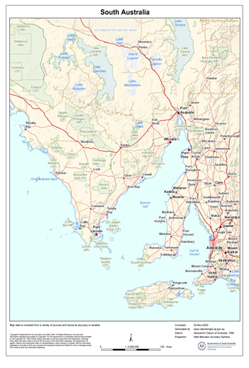
Southern South Australia. Eyre Peninsula runs from Streaky Bay and Whyalla in the north southward to Port Lincoln; Yorke Peninsula is boot shaped, west of Adelaide across Gulf St Vincent, with Kangaroo Island is to its south. Spencer Gulf is located between these two peninsulas. The Great Australian Bight is west of Eyre Peninsula. (Prepared by D E W: Mapland. South Australia. November 2020)
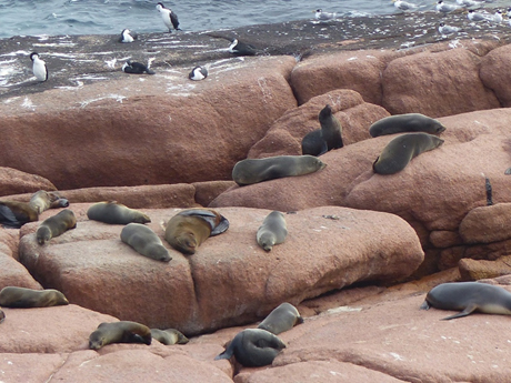
Sea lions on the granite platform at Point Labatt (south of Streaky Bay) with crested tern (top right) and pied cormorants (top left). 2019.

The west or Bight coast of Eyre peninsula is subjected the open waters of the Great Australian Bight and the persistent high energy waves of the Southern Ocean.  At Point Labatt for example, just south of Steaky Bay on the northwest of the peninsula, wave action has exposed a smooth wave-washed granite platform favoured by sea lions.

Over time waves have removed the overlying consolidated coastal dunes called aeolianite leaving high cliffs of this rock as the shoreline. The local aeolianite rock specifically known as calcarenite is common along the Peninsula coastline (and most other coastlines of southern and western Australia) and was blown into position (hence the name aeolianite) during the lowered sea level of the Pleistocene (2.6 Ma -10,000 years ago). Sea levels were up to 125 m lower during the last Pleistocene ice ages so allowing onshore wind to accumulate calcium carbonate (limestone) dominated sand to be swept up from the then exposed sea floor sediments. The calcium carbonate originating from shell, coralline algae, microscopic forams and other marine organisms acted like cement to produce the calcarenite. In addition to forming on land, calcarenite also formed in offshore positions to became reefs and islands once sea levels rose and stabilised some 6,600 years ago.

This phenomenon provides and interesting time difference in the formation of local rocks.  The coarse-grained red granite, based on two measurements, was formed of between 1456 and 1478 Ma (million years ago before present). Gawler Ranges Volcanics were formed about 1580 Ma) and in places have been intruded by the granite and the rhyolite. The calcarenite was formed over 1.5 billion years later!
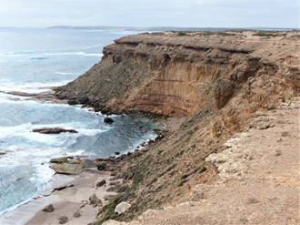
Typical calcarenite cliffs along the west coast of Eyre Peninsula

Granite has also been exposed inland and there are a series of very interesting granitic landforms on the north western side of the Peninsula including Murphy Haystacks south of Steaky Bay; a variety of granitic formations in the Wudinna Hills; with flared slopes and caves (tafoni) at Ucontitchie Hill southwest of Wudinna.    

Granite is an intrusive rock and is pushed in its molten state as magma to form underground structures called batholiths. These vary in dimension and may be eventually exposed at the surface once the covering rocks are weathered and eroded away. Granite may also be exposed by uplift during a mountain building event.

Prior to their exposure underground weathering may have taken place this process beginning on the edges or corners of joints in the rock. In effect this rounds-off the blocks so they appear like Murphy Haystacks if small, or as huge, rounded mountain ranges such as near Mt Wudinna to their north. Flared slopes are also a result of subsurface weathering that relies on water that has run off the exposed section and adds to the underground moisture level and conditions conducive to weathering. The flare is exposed once the ground level drops after surface erosion. Tafoni (hollows and caves) begin in a similar fashion and if tafoni are cavernous enough when exposed above ground their internal atmosphere may in fact retain enough moisture in the space for slow weathering to continue.

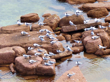
A few of Murphy Haystacks, Eyre peninsula.
The rounded blocks of granite are ideal roosts for crested tern. Cape Labatt Conservation Park, Eyre Peninsula, SA.

When walking across granite surfaces gnammas are often encountered. These depression may be quite shallow or measure metres across and be deep enough to be called pits and arm-chairs! Clearly these form as a result of ongoing weathering in a depression that holds water. The name gnamma is derived from a Western Desert Aboriginal language in WA and as may be imagined deeper pits could serve as a temporary drinking water source.

Port Lincoln and Iron Knob

Port Lincoln is the major centre located in the far south of the Eyre peninsula where there is an active port with fishing vessels and large grain exporting ships. This was designated by the surveyor, Colonel Light in 1836 to be the site for the capital of the new colony of South Australia. However when Light visited the harbour during a gale he deemed it unsuitable and reverted his decision to a site near Holdfast Bay. 

Port Lincoln is close to two large national parks, Coffin Bay National Park and Lincoln National Park, both with interesting walks and drives for visitors. Whalers Way is not a dedicated reserve but offers a most interesting drive through private land southwest of Port Lincoln. This is easily accessed with great coastal scenery from several lookouts. The area also has historic connections to Matthew Flinders and Nicolas Baudin and the whaling industry. Several remarkable geological features are found along the coast especially Theakstone Crevasse, the 120 m high calcarenite cliffs, as well as fascinating coloured rocks at Redbanks and at Cape Carnot on the most southerly part of the Peninsula.

The rocks at Cape Carnot were once considered to be  the oldest rocks in South Australia (2.64 billion years old) -until the record was broken in 2008 by a find in the Middleback Ranges near Iron Knob at the north eastern corner of Eyre Peninsula. This new find recorded 3.15 billion years old.

Geologically this area is within the Gawler Craton and in 2008 geologists collected samples from granite on a transect located between Iron Knob and Iron Baron. Zircon crystals from the granite were recovered and subjected to an analysis technique known as Sensitive High-Resolution Ion Microprobe (SHRIMP), which measures the minute quantities of Uranium and Lead isotopes in the sample. These measurements enable geologists to determine the age of the mineral and in this case the age of the rock from which it came. To their great surprise the samples were dated to 3,150 Ma. Repeated testing produced the same result and so established that this was the oldest rock yet found on this side of the Continent. By way of comparison, the oldest rock in the world (from 4.28 Ma ago) comes from northern Quebec, Canada. In Western Australia at a location known as Jacks Hill zircon crystals have been dated at 4,400 Ma but given that the zircon came from a mixed gneiss sample, geologists considered it was not possible to say from exactly what type of rock it had originated from. 

Prospective minerals and metals in the Middleback Range include jade, marble, copper lead, zinc, uranium and manganese but only the iron ores found here are considered to be economically worth recovering. Iron Knob, the name of a township and an Iron ore mine in the Range is inland from Whyalla. Iron Knob mine is an open-cut pit mining two iron ores, magnetite and hematite.  The magnetite is smelted in Whyalla but the hematite is exported.  There are several other mine operations and potential mining sites along the range including one at Iron Baron. For most of this region rock formations were laid down over 2000 Ma under a shallow primeval sea.

Spencer Gulf, Gulf St Vincent and Yorke Peninsula

Spencer Gulf separates Eyre and Yorke Peninsulas, which is tidally influenced by the Southern Ocean but is fairly well protected from the wave generating westerly winds influencing wave generation on the Great Australian Bight coastline as experienced on the western side of Eyre Peninsula and the southern coastline of Kangaroo Island.

Just as Spencer Gulf had been named after a British Earl, Gulf St Vincent was also named by Flinders in 1802 after a British admiral who was the Earl of St Vincent. Gulf St Vincent is the smaller of the two and is connected to the Southern Ocean primarily by Investigator Strait and the much small Backstairs Passage at the eastern end of Kangaroo Island. Gulf St Vincent has Adelaide Plains on its northeast and the Fleurieu Peninsula to the south east.
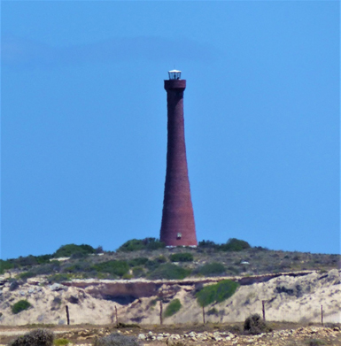
A rare brick lighthouse at Troubridge Hill built in 1980 to replace the light on Troubridge Island. At south eastern ‘heel’ of Yorke Peninsula facing Investigator Strait, Kangaroo Island and Backstairs Passage.

In the 1840s prior to European settlement and reaching to the south of Yorke Peninsula there were four Traditional Owner clan groups of the Narungga people who occupied the Yorke Peninsula for thousands of years. They were the Kurnara of the north, the Windera of the east, the Wari of the West and the Dilpa (Dhilba) of the south. Guuranda.
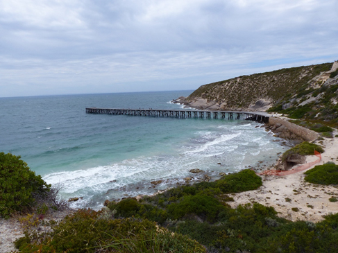
Historic jetty at Stenhouse Bay -once a significant port for exporting gypsum. Innes National Park, Yorke Peninsula.

European settlers around the gulfs once relied on seaports for incoming goods, services and transport, along with the export of products like grain, wool, livestock and minerals. Commercial fishing was active in several locations and remains an important industry of the area. Road transport has essentially taken over most of these needs leaving just Port Lincoln, Whyalla and Port Pirie as functioning commercial ports today on Eyre Peninsula and the upper Spencer Gulf. Around Spencer Gulf there are a few ports specialising in a single export function. Ardrossan, Wallaroo and Port Giles are wheat handling ports; Turton and Port Broughton are used by the fishing boats; and Klein Point is used specifically for the limestone being shipped to Adelaide for cement production.

Like most of Eyre Peninsula, cropping is a major rural activity on Yorke Peninsula with wheat, canola, barley and lentils being the most common grain crops, with many hectares also being devoted to hay and pasture production.

Given that South Australia is the Continent’s driest state it is not surprising that catchment dams for domestic supplies would be quite unreliable. To overcome this problem water had been pumped from the Murray River at either Morgan or Swan Reach west to Yorke and Eyre peninsulas. One of the early pipelines (1940) was the Morgan -Whyalla connection to enable a reliable supply of water for steel production. Since then other Murray River water pipelines have been constructed with extensions to many towns and properties on both Peninsulas and elsewhere in South Australia. For some time Eyre Peninsula had relied on winter rainfall catchment reservoirs (e.g. Tod) and underground resources with some quite simple water catchment systems built around bare granite slopes to harness runoff as seen near Minnipa and Wudinna in the northern Eyre Peninsula.

Main pipelines from the Murray River; note that this water may supplement local supplies in some localities from underground water, natural run-off and desalination plants. The Flinders News, Port Pirie. (Source Wikipedia Commons).

Ores and Minerals

The north and western part of South Australia has considerable mineral wealth mainly due to is connection with the Gawler Craton. The most prominent of these are the Iron ore resources from Middleback Range with Copper, Uranium, Silver and Gold as mined at Olympic Dam at the northern end of the Craton. Outside the craton’s influence.

Burra was a major copper ore producer after its discovery in 1845 until 1977 and in the Kadina-Wallaroo-Moonta area copper ore was discovered in 1860-61. This latter area is often referred to as the ‘copper triangle’, ‘copper coast’ or ‘little Cornwall’ because of the number of emigrant Cornish miners who originally worked in the area. The copper ore was smelted at Wallaroo and easily exported from the local port. Port Pirie lead smelter is a major ongoing plant and has been active since 1880 treating not locally sourced ore but that brought in by rail over the SA border from Broken Hill in New South Wales.

While not an ore, Gypsum has been mined at several locations on both Eyre and Yorke Peninsulas and this continues as an export product from Lake MacDonnell near Ceduna. In the 1880s gypsum was discovered and mined at the southern tip of Yorke Peninsula and many remnants of the original industry are now ‘preserved’ in Dhilba Guuranda-Innes National Park. The jetty in Stenhouse Bay, now heritage listed, was originally used to export bags of gypsum.
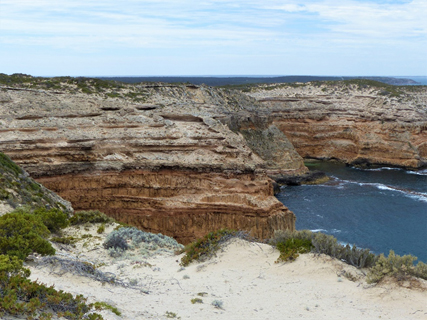
Looking over white cliff-top sand at the Aeolianite/Calcarenite Cliffs, Dhilba Guuranda-Innes National Park
Lighthouse at Cape Spencer the most southern point on the Peninsula looking toward Seal Island. Dhilba Guuranda-Innes National Park, Yorke Peninsula.

Dhilba Guuranda-Innes National Park also takes in a wide variety of spectacular coastal scenery, a lighthouse and inland mallee woodlands which provide habitat for a range of endangered bird species including the malleefowl. The tammar wallaby that had become extinct on the mainland since 1920, was successfully re- introduced to the park in 2004 from the offspring of animals re-introduced to Australia from New Zealand.  The name of the park has recently changed from Innes National Park in acknowledgment  of the traditional owners of this area and their role in joint management of the Park.

Flinders Ranges, South Australia – Background briefing landscapes and natural history

Background briefing – The Flinders Ranges, South Australia Notes for travellers on the landscapes and natural history #4

Flinders Ranges- European discovery and naming 
Rocks and Landforms -old and diverse
Drive through Brachina Gorge -a journey in time

Fossils
Modern Plants and Animals in the Flinders
Arkaroola and the Gammon Range
A W (Sandy) Scott. Nov. 2020

Inland from the Fleurieu, Yorke and Eyre Peninsulas of South Australia are two interesting travel destinations that have qualities attractive to nature loving adventurers and to geologists. In the west are the Gawler Ranges and in the east are the Flinders Ranges, and the latter are the focus of this article.

Southern South Australia showing Eyre, Yorke and Fleurieu Peninsulas (EP, YP & FP) along with the Gawler Ranges (GR) and the Flinders Ranges (FR) Map prepared by DEW, Mapland, South Australia. Nov. 2020

Flinders Ranges- European discovery and naming 

The Flinders Ranges were named after Matthew Flinders during his sea survey explorations along the south coast of Australia in 1802. In Investigator Flinders sailed to the north of Spencer Gulf, about 30 km south current Port Augusta and realising the Gulf was narrowing and getting shallower anchored in Yatala Harbour. Next day a shore party, led by his naturalist/botanist Robert Brown, along with landscape artist William Westall, gardener Peter Good, illustrator Ferdinand Bauer, geologist John Allen and two servants walked northward over the hills to climb what was later named by Flinders, Mount Brown (960 m). 

From this point near the southern end of the Flinders Ranges, Brown would have observed the high country to his east continued to the north but unlike the Adnyamathanha traditional owners of this hill country, neither he nor the rest of the shore party would have had any idea of their total extent. In fact, we now know that this string of mountain ranges extends over 400 km from north to south. In a report, published 1839, State Governor George Gawler referred to these ranges as, ‘Flinders Ranges’, a feature now very well-known and regularly visited by South Australians and on the ‘wish-list’ for many other travellers from further afield.

While Brown walked inland, Flinders travelled by cutter with his surgeon Hugh Bell to explore locations at the head of Spencer Gulf. They spent overnight just short of the present location of Port Augusta and next morning they progressed north until the boat men’s ores could touch the side of the channel -they had arrived at the head of Spencer Gulf.

Today this point appears to be about 10km north of Port Augusta. A little south of this point Flinders stopped to take compass bearings, and one of his key points was Mount Arden (839m), north-northeast of their current position on the western side of the Flinders Ranges and almost due north of Mount Brown.

Rocks and Landforms -old and diverse

The rock formations in Flinders Ranges, like the Mount Lofty Ranges to their south, began within an extended period (870 Ma (million years ago) to about 500 Ma) over which several types of sediments were deposited in shallow waters by rivers in a series of slowly sinking shallow troughs. Over time the compressed sediments became the sandstone, quartzite, limestone, siltstone and mudstone, rocks we see making up the ranges formation today.

Subsequent earth movements pushed the sedimentary rock formations from their original horizontal position upwards with much fracturing and folding of the rock to form hills and valleys. Once exposed, weathering and erosion removed the less resistant rocks like siltstone leaving the formations of harder sandstones and quartzite. It is the latter rock types that are most visible where they protrude as ridges and crags or get exposed following creek bank erosion. Valleys have often developed where the ’softer’ sediments were once found.

Folding occurs when earth movements compress the formations horizontally to form wave like patterns with crests (anticlines) and troughs(synclines). The syncline that forms the magnificent feature Wilpena Pound, is dish shaped and several kilometres across. On a much smaller scale we also see folded rock with just metres between successive anticlines.

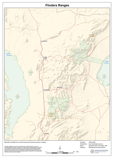
Flinders Ranges located between Lake Frome to the east and Lake Torrens to the west. Map prepared by DEW, Mapland, South Australia. Nov. 2020
L. A series of anticlines and synclines;
R. A syncline and landforms
Wilpena Pound, view from Wangara Lookout, Ikara-Flinders Ranges National Park. This dish-like landform is a syncline and the rising sides encircling the Pound were once part of the anticline, now removed by weathering and erosion.

Folding has been a most important process in the origin of many local landforms with several of the fractured upswept masses becoming cliffs at the top of ridges as in the Flinders’ Great Wall of China.

The cliff top, Great Wall of China, Ikara-Flinders Ranges National Park
A typical cuesta with its gently sloping dip slope of ‘resistant’ sedimentary rock with the formation of an escarpment/cliff above the steeper side formed on the underlying ‘softer’ sedimentary rock. North of Brachina Gorge.

Earth movements producing faulting, may compress or stretch brittle rock formations resulting in joints that divide the original horizontally positioned rock strata into displaced blocks of rock with one side of the fault rising above an originally flat surface. Alternatively, the original formations may be subjected to sideways forces that move parts laterally horizontal with displacement along the fault line ranging from a few centimetres to many kilometres.

The two main types of faulting showing both vertical and horizontal movements/ (Wikipedia Commons)

Over time weathering, erosion and soil formation may mask past faulting but when recognised by a geologist is represented on maps as straight black lines. On the other hand with folded rocks, anticlines are indicated of a map as a pair of arrows pointing in opposite directions and synclines as two arrows pointing toward each other.

Drive through Brachina Gorge -a journey in time.

Driving along Brachina Gorge displays many of the physical features mentioned above and folding has exposed a sequence of 17 different rock formations by tilting them from a horizontal position with the youngest formations at the top in the west and successively older formations beneath.

When travelling from east to west all 17 tilted formations are crossed beginning at the eastern end with the oldest, Precambrian rock, and ending with a limestone from the Cambrian Period formed 130 Ma later. Explanatory interpretation boards along the way name and describe the diverse formations.

One of the many interpretation notices along Brachina Gorge.

The gorge has been cut down through the weathering and erosion actions of Brachina and several smaller creeks with the eroded sediments being carried westward out of the gorge and across the slopes toward Lake Torrens. In many cases the direction of the creek is influenced by the resistance of rock to weathering -with the most resistant formations causing the creek to change direction. During the hotter seasons the bed of the creek (which serves as the road in places) is generally dry.

Fossils

Two of the rock formations in Brachina Gorge bear fossils of great age. The oldest of these are Stromatolites a life form that grew as thin films of Cyanobacteria, bacteria like organisms, that lived in shallow saline sea and able to carry out photosynthesis. The films of cells collect and bind with sediments to forms multilayers that build up over 1,000s of years and depending on the species of Cyanobacteria involved, form a solid cemented flat, cone shaped or dome like structures.

While these particular Stromatolite fossils lived less than 1,000 Ma (Millions of years ago)  older members of this group, found elsewhere, are known to have been 2,500 Ma old making them one of the earliest organisms. Their significance does not end there.  Photosynthesis results in the-production of Oxygen and over the millions of years Stromatolites oxygenated the water. Once saturated oxygen  ‘escaped’ for the water to  the atmosphere so providing a habitat suitable for a new suite of organisms -the aerobes.  Aerobes are organisms that survive and grow in an oxygenated environment.

Conical fossil stromatolites from ca. 1650 Ma. Abner Range, West of Cape Crawford, Northern Territory.

Modern day relatives of these Stromatolite species are found in shallow hypersaline waters that are also very rich in calcium carbonate leached from the local sand that is itself carbonate rich. The best known stromatolites are those in Hamlin Pool at the southern tip of Shark Bay.

Stromatolites in Hamlin Pool, Shark Bay, Western Australia. The distant beach is dominated from calcium carbonate rich sand.
A close image of the multilayers of a dome-shaped Stromatolite fossil, Brachina Gorge.

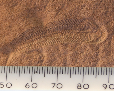
The other set of local fossils of note along Brachina Gorge are the Ediacaran group, the world’s first complex multicellular animal life with specialised tissue. These fossils formed as casts on the surface of stromatolite mats and are most numerous in the last phase of the Neoproterozoic Era, the recently named Ediacaran Period lasting from 635 Ma to 541 Ma. Early studies believed that their soft bodies bodies were preserved as fossils by being enclosed in fine sediments however the details of their fossilisation is far from settled.

Ediacaran species vary in shape and oval ones may range in diameter from 1 to 70 cm. Species are relatively wide-spread and found as fossils in Russia, Canada, Mexico, England and Ireland. They were first discovered by South Australian geologist Reg Sprigg in 1946 and have been named after the Ediacaran Hills on the western side of the north Flinders Ranges where Reg made the discovery of what he initially thought was a sea jelly (jellyfish) fossils. The rock bearing these fossils is also found in the Flinders Ranges and is known as the Trezona Formation. It is exposed in Brachina Gorge and reveals Ediacaran fossils.  

Dickinsonia costata, an Ediacaran organism
Spriggina, another Ediacaran genus, may be one of the predators that led to the demise of the Ediacaran fauna.(Wikipedia Commons).

A Golden Spike is ‘(a) geologic marker created by a global event that leads to long lasting global changes recorded in the geologic record that can be used to indicate a change in a geologic time division such as an epoch, age, era.’ (Wikipedia Commons). One of these spikes is found in the Flinders Ranges indicating the geological importance of this discovery.

This ‘spike’ is the 64th in the World, it marks the discovery of the rock strata in which Ediacarans are found and what is now recognised as Ediacaran Period from 635 Ma to 541 Ma.  The spike was embedded near Ediacaran fossils along Trezona Creek, off the Brachina Gorge Road in the Flinders Ranges in 2004. South Australia may therefore claim this as a ‘First’ for itself, Australia and the Southern Hemisphere given that most other similar geological events (e.g. for the Jurassic, Ordovician, Cambrian and Devonian Periods ) were over a century ago in Europe, Britain and north America when identifying newly found rock formations and their fossils.

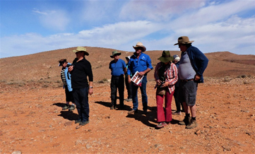
A wide range of Ediacaran species were also discovered on Nilpena Station south of the Ediacara Hills (a western outlier of the Flinders Ranges). Very recently some 60,000 ha of this property was purchased through South Australian Government sources and private donations and this has been set aside as the Ediacara Conservation Park (and hopefully out of reach of illegal fossil hunters). This site is currently under scientific investigation and may only be visited in organised groups.

Group about to visit the fossil site on Nilpena Station with property owner and guide Ross Fargher.

Modern Plants and Animals in the Flinders

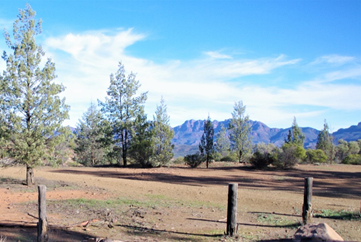
The landscape diversity in the Flinders has resulted in a great variety of plant communities. The mostly dry creeks for example are lined with huge river red gums or upland woodlands of cypress pine. While the National Parks generally support natural plant and animal communities many other parts of the Flinders Ranges have been cleared and used for sheep grazing.

River red gums (Eucalyptus camaldulensis) roadside above Brachina Creek.
White Cypress-pine (Callitris glaucophylla), Bunyeroo Valley Lookout.
Grass trees (Xanthorrhoea quadrangulata) on stony hillside in Ikara-Flinders Ranges National Park

Following winter rain hectares of land in Ikara-Flinders Ranges National Park is often covered with masses of blue flowered salvation Jane (Echium plantagineum) , an introduced plant usually considered to be a weed and so it is given its alternate common name, Patterson’s curse. The natural vegetation of the floor of Wilpena Pound, a well visited site in the south of the Park, is dominated by a low woodland of White Cypress-pine and Eucalyptus intertexta, commonly known as gum-barked coolabah, with many other understory shrubs and herbs including salvation Jane. Most of the native plants have regenerated since sheep grazing and cropping ceased within the Pound and more generally within the Park as a whole.

Emus and red and grey kangaroos are plentiful on the grassy plains, euros (hill wallaroos) on rocky outcrops and flocks birds like galahs and white corellas are common. Beside these more common species the yellow-footed rock-wallaby may be spotted high up rocky crags and there are many smaller bird species and reptiles for those willing to sit and look.

Arkaroola and the Gammon Ranges

Within the main section of the Flinders Ranges, Blinman is the main central settlement, Hawker is to the south and Arkaroola is in the north Flinders. The Ikara-Flinders Ranges National Park in the central-north of the Ranges has a large campground and resort and its most popular attraction, Wilpena Pound, in at its southern end. Ransley Park Station, another well visited centre is just outside the park to its south.

Like the other settlements Arkaroola is a popular destination for travellers and has many attractions related to wildlife, astronomy, mining history with several interesting drive and walking opportunities. This northern section of the Flinders Ranges is often referred to as the Gammon Ranges, and the Vulkathunha-Gammon Ranges National Park is just to the south of Arkaroola.

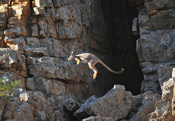
Yellow-footed rock wallaby (Petrogale xanthopus) in its normal habitat, Flinders Ranges. Australian Wildlife Conservancy (Wikipedia Commons).
Gammon Ranges in the northern Flinders Ranges and Arkaroola Prepared by DEW, Mapland, South Australia (Nov. 2020)

Arkaroola was bought as a property by Reg Sprigg and family with the aim of creating a wilderness sanctuary. About the time of purchase (1968) feral goats were numerous and a threat to the yellow-footed rock wallaby. The goats lived on similar shrub and grasses to the wallaby and sheltered in the caves and overhangs of rocky outcrops the wallabies used as their cool daytime retreats. At the time of purchase feral donkeys and camels were also common in the area, foxes were numerous along with feral cats. Foxes and cats posed a direct threat particularly to young wallabies.

Fencing and elimination of the large mammals was successful with poisoning and shooting to reduce fox and cat numbers.  Regaining their habitats and the removal of predators has allowed the rock wallaby to resume its habitats on Arkaroola. A depletion of foxes and feral cat numbers help reduce the threat to other small mammals like several bat species, species of the dunnart (a small carnivorous marsupial), smaller reptiles and many bird species.

For the visitor there are accommodated and camping facilities and many spectacular hill-top views including those across to Lake Frome. There are hot springs at Paralana north of Arkaroola and their Radium content indicates the presence of radioactive minerals. Geologists believe Uranium from here was leached from its source and accumulated in ancient drainage channels in economic proportions away from the hills. This is now extracted at the Beverley Mine located east of the hilly country about 35 km from Arkaroola. Here the mineral is brough to the surface, not through digging, but pumped in an acid solution from which the ore may be then extracted.

Copper mining and processing also occurred just west of Arkaroola and the industrial ruins may be visited to see the two brick furnaces in which the copper ore was smelted at Bolla Bollana in the mid-1870s.