Gawler Ranges
Eyre Peninsula,
Port Lincoln and Iron Knob
Spencer Gulf, Gulf St Vincent and Yorke Peninsula
Ores and Minerals
A W (Sandy) Scott. Nov. 2020
Gawler Ranges
In Australia there are three original stable and ancient landmasses (cratons) about which the rest of the continent has developed. Two of these, the Pilbara and the Yilgarn cratons are in Western Australia (WA) and the third, the Gawler Craton, is found in South Australia (SA). The Gawler craton is younger that those in WA with a section beginning 2450 Ma (millions of years ago) and it had stabilised by 1450 Ma. This craton underlies all of the Eyre Peninsula in SA reaching north near Olympic Dam, westward around the eastern part of the Great Australian Bight and eastward it stretches across toward the Adelaide Geosyncline at Whyalla and east of Lake Gairdner.

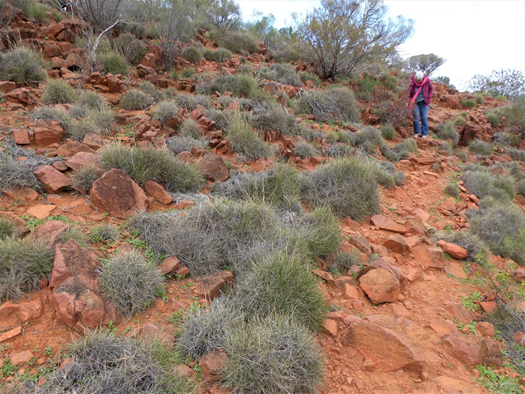
The central section of the Gawler Craton was flooded around 1,600 Ma with volcanic lava flowing out from vents rather than volcanic cones. Shortly after there were some extrusions of Rhyolite which on cooling formed organ-pipe columns. The volcanic rocks, like Dacite, are well exposed especially on hills and other high country and have a beautiful red coloration resulting from the weathering of its iron-rich mineral components. Both the Volcanics and the Rhyolite are features in the Gawler Ranges National Park and other sections of the Gawler Ranges like Mt Ive.
[Mount Ive is the name of a landform and of a sheep station. Here the owners have upgraded some of its worker accommodation which is available to travellers. This property also holds the key allowing access to the National Park reserve area enclosing the southern section of Lake Gairdner.]


Lake Gairdner is a salina -an ephemeral, salt dominated lake – with the ‘vital statistics’ of being some 160km long, about 48km at its widest point, with no external drainage points and, when dry, has a crystalline salt surface over a metre deep. When the lake fills it rates as Australia’s third largest. A recent visit to the lake was spectacular with the red of the surrounding hills contrasting with the brilliant white of the salt (mostly sodium chloride) that covered the entire dry lake surface.
Eyre Peninsula
This large triangular shaped peninsula and is underlain by the southern extension of the Gawler craton incorporating ancient crystalline rocks, including gneiss, granite and metamorphosed sediments that are exposed in many places, especially around the coastline.
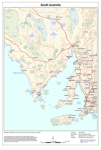
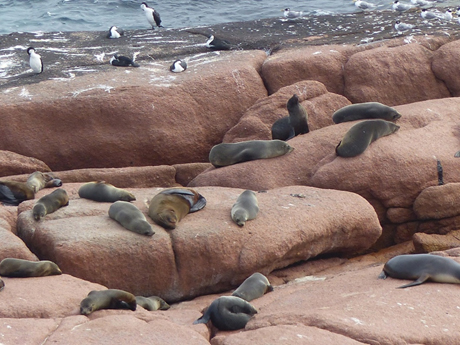
The west or Bight coast of Eyre peninsula is subjected the open waters of the Great Australian Bight and the persistent high energy waves of the Southern Ocean. At Point Labatt for example, just south of Steaky Bay on the northwest of the peninsula, wave action has exposed a smooth wave-washed granite platform favoured by sea lions.
Over time waves have removed the overlying consolidated coastal dunes called aeolianite leaving high cliffs of this rock as the shoreline. The local aeolianite rock specifically known as calcarenite is common along the Peninsula coastline (and most other coastlines of southern and western Australia) and was blown into position (hence the name aeolianite) during the lowered sea level of the Pleistocene (2.6 Ma -10,000 years ago). Sea levels were up to 125 m lower during the last Pleistocene ice ages so allowing onshore wind to accumulate calcium carbonate (limestone) dominated sand to be swept up from the then exposed sea floor sediments. The calcium carbonate originating from shell, coralline algae, microscopic forams and other marine organisms acted like cement to produce the calcarenite. In addition to forming on land, calcarenite also formed in offshore positions to became reefs and islands once sea levels rose and stabilised some 6,600 years ago.
This phenomenon provides and interesting time difference in the formation of local rocks. The coarse-grained red granite, based on two measurements, was formed of between 1456 and 1478 Ma (million years ago before present). Gawler Ranges Volcanics were formed about 1580 Ma) and in places have been intruded by the granite and the rhyolite. The calcarenite was formed over 1.5 billion years later!
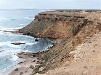
Granite has also been exposed inland and there are a series of very interesting granitic landforms on the north western side of the Peninsula including Murphy Haystacks south of Steaky Bay; a variety of granitic formations in the Wudinna Hills; with flared slopes and caves (tafoni) at Ucontitchie Hill southwest of Wudinna.
Granite is an intrusive rock and is pushed in its molten state as magma to form underground structures called batholiths. These vary in dimension and may be eventually exposed at the surface once the covering rocks are weathered and eroded away. Granite may also be exposed by uplift during a mountain building event.
Prior to their exposure underground weathering may have taken place this process beginning on the edges or corners of joints in the rock. In effect this rounds-off the blocks so they appear like Murphy Haystacks if small, or as huge, rounded mountain ranges such as near Mt Wudinna to their north. Flared slopes are also a result of subsurface weathering that relies on water that has run off the exposed section and adds to the underground moisture level and conditions conducive to weathering. The flare is exposed once the ground level drops after surface erosion. Tafoni (hollows and caves) begin in a similar fashion and if tafoni are cavernous enough when exposed above ground their internal atmosphere may in fact retain enough moisture in the space for slow weathering to continue.

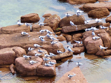
When walking across granite surfaces gnammas are often encountered. These depression may be quite shallow or measure metres across and be deep enough to be called pits and arm-chairs! Clearly these form as a result of ongoing weathering in a depression that holds water. The name gnamma is derived from a Western Desert Aboriginal language in WA and as may be imagined deeper pits could serve as a temporary drinking water source.
Port Lincoln and Iron Knob
Port Lincoln is the major centre located in the far south of the Eyre peninsula where there is an active port with fishing vessels and large grain exporting ships. This was designated by the surveyor, Colonel Light in 1836 to be the site for the capital of the new colony of South Australia. However when Light visited the harbour during a gale he deemed it unsuitable and reverted his decision to a site near Holdfast Bay.
Port Lincoln is close to two large national parks, Coffin Bay National Park and Lincoln National Park, both with interesting walks and drives for visitors. Whalers Way is not a dedicated reserve but offers a most interesting drive through private land southwest of Port Lincoln. This is easily accessed with great coastal scenery from several lookouts. The area also has historic connections to Matthew Flinders and Nicolas Baudin and the whaling industry. Several remarkable geological features are found along the coast especially Theakstone Crevasse, the 120 m high calcarenite cliffs, as well as fascinating coloured rocks at Redbanks and at Cape Carnot on the most southerly part of the Peninsula.
The rocks at Cape Carnot were once considered to be the oldest rocks in South Australia (2.64 billion years old) -until the record was broken in 2008 by a find in the Middleback Ranges near Iron Knob at the north eastern corner of Eyre Peninsula. This new find recorded 3.15 billion years old.
Geologically this area is within the Gawler Craton and in 2008 geologists collected samples from granite on a transect located between Iron Knob and Iron Baron. Zircon crystals from the granite were recovered and subjected to an analysis technique known as Sensitive High-Resolution Ion Microprobe (SHRIMP), which measures the minute quantities of Uranium and Lead isotopes in the sample. These measurements enable geologists to determine the age of the mineral and in this case the age of the rock from which it came. To their great surprise the samples were dated to 3,150 Ma. Repeated testing produced the same result and so established that this was the oldest rock yet found on this side of the Continent. By way of comparison, the oldest rock in the world (from 4.28 Ma ago) comes from northern Quebec, Canada. In Western Australia at a location known as Jacks Hill zircon crystals have been dated at 4,400 Ma but given that the zircon came from a mixed gneiss sample, geologists considered it was not possible to say from exactly what type of rock it had originated from.
Prospective minerals and metals in the Middleback Range include jade, marble, copper lead, zinc, uranium and manganese but only the iron ores found here are considered to be economically worth recovering. Iron Knob, the name of a township and an Iron ore mine in the Range is inland from Whyalla. Iron Knob mine is an open-cut pit mining two iron ores, magnetite and hematite. The magnetite is smelted in Whyalla but the hematite is exported. There are several other mine operations and potential mining sites along the range including one at Iron Baron. For most of this region rock formations were laid down over 2000 Ma under a shallow primeval sea.
Spencer Gulf, Gulf St Vincent and Yorke Peninsula
Spencer Gulf separates Eyre and Yorke Peninsulas, which is tidally influenced by the Southern Ocean but is fairly well protected from the wave generating westerly winds influencing wave generation on the Great Australian Bight coastline as experienced on the western side of Eyre Peninsula and the southern coastline of Kangaroo Island.
Just as Spencer Gulf had been named after a British Earl, Gulf St Vincent was also named by Flinders in 1802 after a British admiral who was the Earl of St Vincent. Gulf St Vincent is the smaller of the two and is connected to the Southern Ocean primarily by Investigator Strait and the much small Backstairs Passage at the eastern end of Kangaroo Island. Gulf St Vincent has Adelaide Plains on its northeast and the Fleurieu Peninsula to the south east.
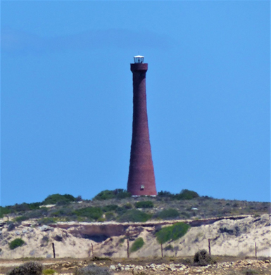
In the 1840s prior to European settlement and reaching to the south of Yorke Peninsula there were four Traditional Owner clan groups of the Narungga people who occupied the Yorke Peninsula for thousands of years. They were the Kurnara of the north, the Windera of the east, the Wari of the West and the Dilpa (Dhilba) of the south. Guuranda.
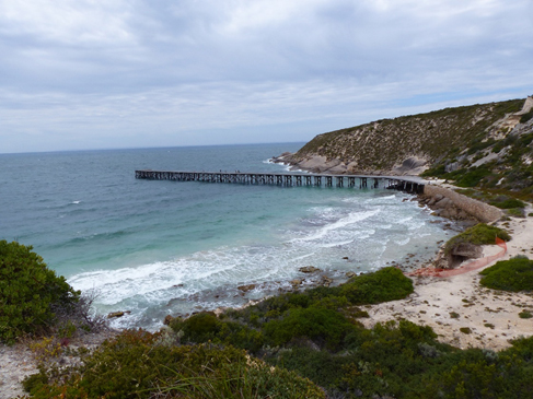
European settlers around the gulfs once relied on seaports for incoming goods, services and transport, along with the export of products like grain, wool, livestock and minerals. Commercial fishing was active in several locations and remains an important industry of the area. Road transport has essentially taken over most of these needs leaving just Port Lincoln, Whyalla and Port Pirie as functioning commercial ports today on Eyre Peninsula and the upper Spencer Gulf. Around Spencer Gulf there are a few ports specialising in a single export function. Ardrossan, Wallaroo and Port Giles are wheat handling ports; Turton and Port Broughton are used by the fishing boats; and Klein Point is used specifically for the limestone being shipped to Adelaide for cement production.
Like most of Eyre Peninsula, cropping is a major rural activity on Yorke Peninsula with wheat, canola, barley and lentils being the most common grain crops, with many hectares also being devoted to hay and pasture production.
Given that South Australia is the Continent’s driest state it is not surprising that catchment dams for domestic supplies would be quite unreliable. To overcome this problem water had been pumped from the Murray River at either Morgan or Swan Reach west to Yorke and Eyre peninsulas. One of the early pipelines (1940) was the Morgan -Whyalla connection to enable a reliable supply of water for steel production. Since then other Murray River water pipelines have been constructed with extensions to many towns and properties on both Peninsulas and elsewhere in South Australia. For some time Eyre Peninsula had relied on winter rainfall catchment reservoirs (e.g. Tod) and underground resources with some quite simple water catchment systems built around bare granite slopes to harness runoff as seen near Minnipa and Wudinna in the northern Eyre Peninsula.

Ores and Minerals
The north and western part of South Australia has considerable mineral wealth mainly due to is connection with the Gawler Craton. The most prominent of these are the Iron ore resources from Middleback Range with Copper, Uranium, Silver and Gold as mined at Olympic Dam at the northern end of the Craton. Outside the craton’s influence.
Burra was a major copper ore producer after its discovery in 1845 until 1977 and in the Kadina-Wallaroo-Moonta area copper ore was discovered in 1860-61. This latter area is often referred to as the ‘copper triangle’, ‘copper coast’ or ‘little Cornwall’ because of the number of emigrant Cornish miners who originally worked in the area. The copper ore was smelted at Wallaroo and easily exported from the local port. Port Pirie lead smelter is a major ongoing plant and has been active since 1880 treating not locally sourced ore but that brought in by rail over the SA border from Broken Hill in New South Wales.
While not an ore, Gypsum has been mined at several locations on both Eyre and Yorke Peninsulas and this continues as an export product from Lake MacDonnell near Ceduna. In the 1880s gypsum was discovered and mined at the southern tip of Yorke Peninsula and many remnants of the original industry are now ‘preserved’ in Dhilba Guuranda-Innes National Park. The jetty in Stenhouse Bay, now heritage listed, was originally used to export bags of gypsum.
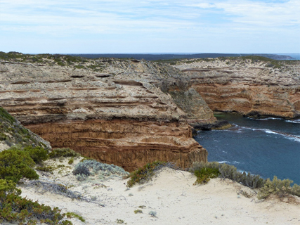

Dhilba Guuranda-Innes National Park also takes in a wide variety of spectacular coastal scenery, a lighthouse and inland mallee woodlands which provide habitat for a range of endangered bird species including the malleefowl. The tammar wallaby that had become extinct on the mainland since 1920, was successfully re- introduced to the park in 2004 from the offspring of animals re-introduced to Australia from New Zealand. The name of the park has recently changed from Innes National Park in acknowledgment of the traditional owners of this area and their role in joint management of the Park.

